


Out of more than a dozen dynamical models depicting ENSO’s future status, only three drop to the threshold to officially declare a La Niña to be underway, while most remain in the neutral zone through next spring. Last winter officially qualified as a La Niña event, although it was a very weak and short-duration event. It could very well see a similar repeat during the upcoming winter, as observed during the 2024–25 season.
The official CPC ENSO probability forecast and the objective model-based IRI ENSO forecast are often quite similar. Significant differences, if any, are attributed to the fact that, at times, human forecasters, using their experience and judgment, may disagree to some degree with the models, which may have known biases. Also, the currency of the forecasters’ assessment and the direct model output may itself differ. The time lag between the two may be subject to change in the starting ENSO conditions and, therefore, the results may not be quite similar.
To catch El Niño/La Niña development, a set of dynamical and statistical models are run. During ENSO, dynamical models are considered better than the statistical ones. Why so? One of the attributes of the dynamical models is that they are run more frequently, using the most recent observed data as input. Many statistical models are built on monthly or seasonal (3-month) average data. So, by comparison, the inputs are relatively older for statistical models, albeit the spread of data is large. As the dynamical models use more and complex datasets, they may catch potentially important changes more authentically than the rest. Overall, the skill of dynamical models is relatively better than that of statistical models but still remains lower than desired levels.
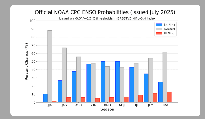
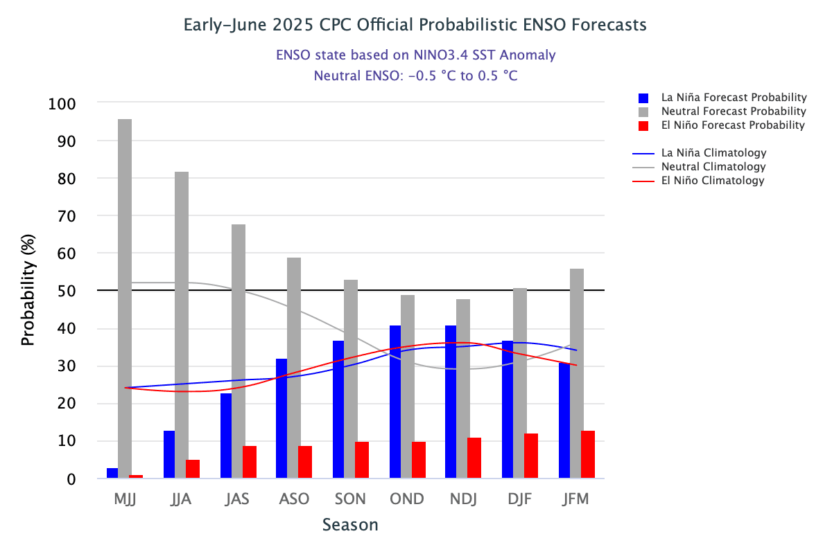
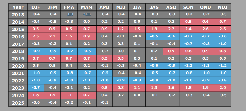
ENSO:The CPC ENSO probability plot for June and July 2025 varies significantly. The July plot shows an increment of La Niña component, more remarkably in the winter quarters Oct–Nov–Dec and Nov–Dec–Jan. It means chances of La Niña cannot be ruled out during the fall of the year. As per these indicators, ENSO may turn neutral again during the Northern Hemisphere spring of 2026.
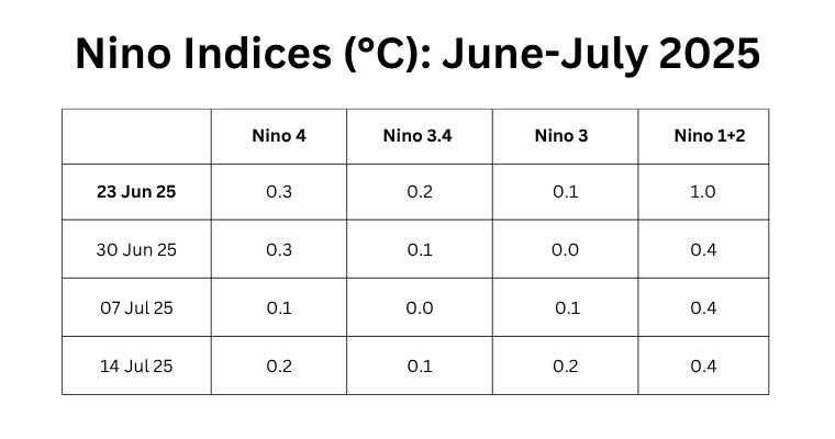
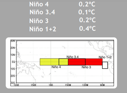
The central equatorial Pacific Ocean has marginally warmed as compared to the previous week. Niño 4, Niño 3.4, and Niño 3 have shown an incremental rise of 0.1°C across the region. Niño 1+2, next to the coastline, retains its anomaly of 0.4°C for the third consecutive week. ENSO conditions remain firmly neutral. The ONI for the quarter Apr–May–Jun preserves its previous value of -0.1°C. At best, it may rise to 0.0°C or 0.1°C in the next two quarters, May–Jun–Jul and Jun–Jul–Aug.
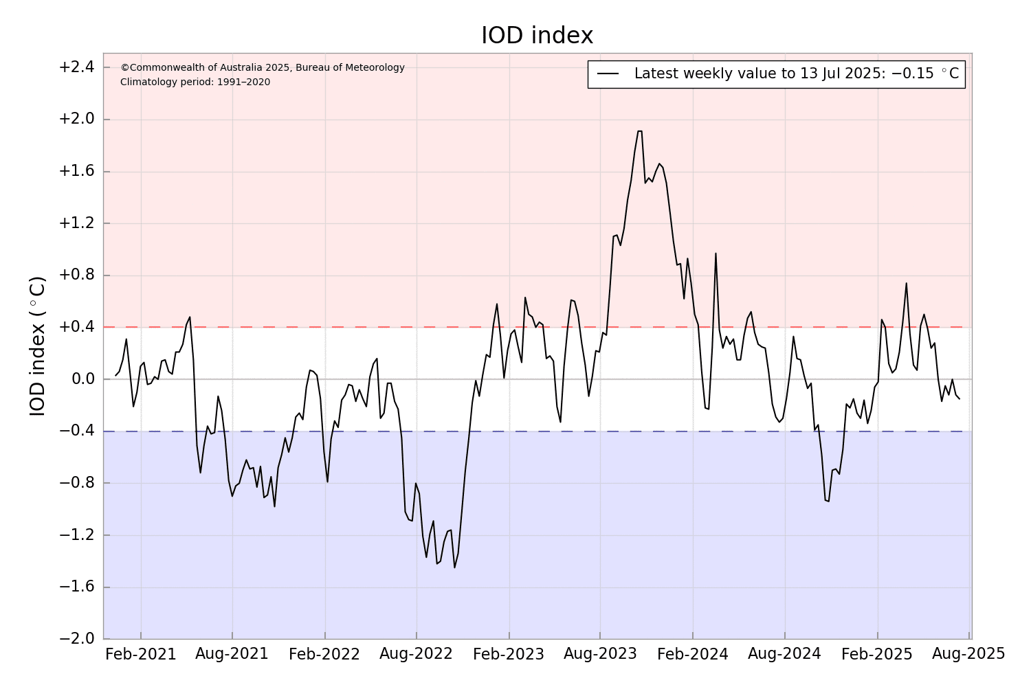
IOD: The Indian Ocean Dipole is neutral. The latest value of the IOD index for the week ending 13 July 2025 was -0.15°C. The index has steadily decreased during May and June but remains within the neutral IOD index range of ±0.4°C. The Bureau’s models predict a neutral state of the IOD until at least August, touching the negative IOD threshold briefly before returning to a neutral state. A majority of models forecast the development of a negative IOD at some point between August and November. Skill for IOD forecasts made at this time of the year has historically been low beyond 2–3 months ahead.
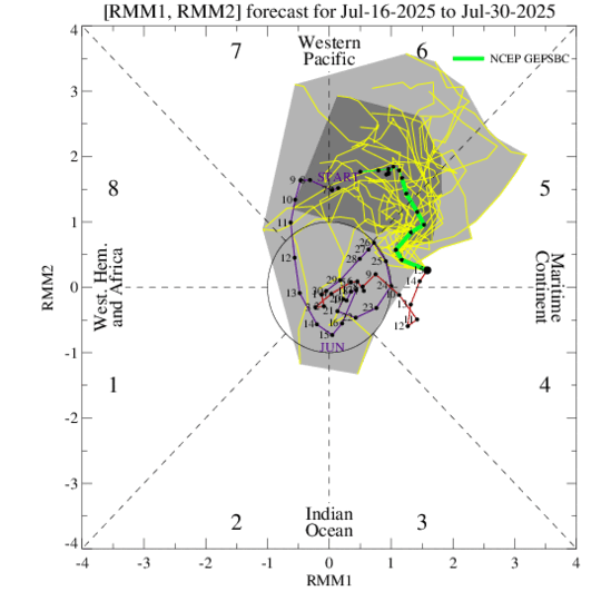
MJO: There are signs of the Madden–Julian Oscillation propagating eastward rapidly and potentially recovering with enhanced amplitude. The dynamical models are also indicating a strengthening of the MJO signal. Revival of the MJO creates a favourable environment for tropical cyclone genesis over the Western Pacific. Earlier, in the first week of July, tropical cyclone DANAS formed in the South China Sea and quickly intensified to become the first typhoon of the 2025 Western Pacific season. DANAS made landfall on the western coast of Taiwan. Indian seas may not find any direct support from the MJO for accentuating convective activity during the last week of July 2025.
The remnant of a storm in the Western Pacific may travel across Thailand and Myanmar during the fourth week of July to enter the Bay of Bengal. The emergence of this system may give a fresh push to the monsoon surge across the country.


