
Pacific Warming Pick Up Strength Ahead Of Strong El Nino


Representational Image: AI-Skymet
Key Takeaways:
- Pacific Ocean warming has intensified significantly since mid-April 2026 across the central and eastern equatorial Pacific.
- Scientists increasingly agree that El Nino formation is likely during 2026, though uncertainty remains regarding peak intensity.
- The IOD is expected to gradually shift toward neutral to positive conditions by mid-July 2026.
- MJO activity is unlikely to significantly support monsoon currents across the Arabian Sea and Bay of Bengal in the near term.
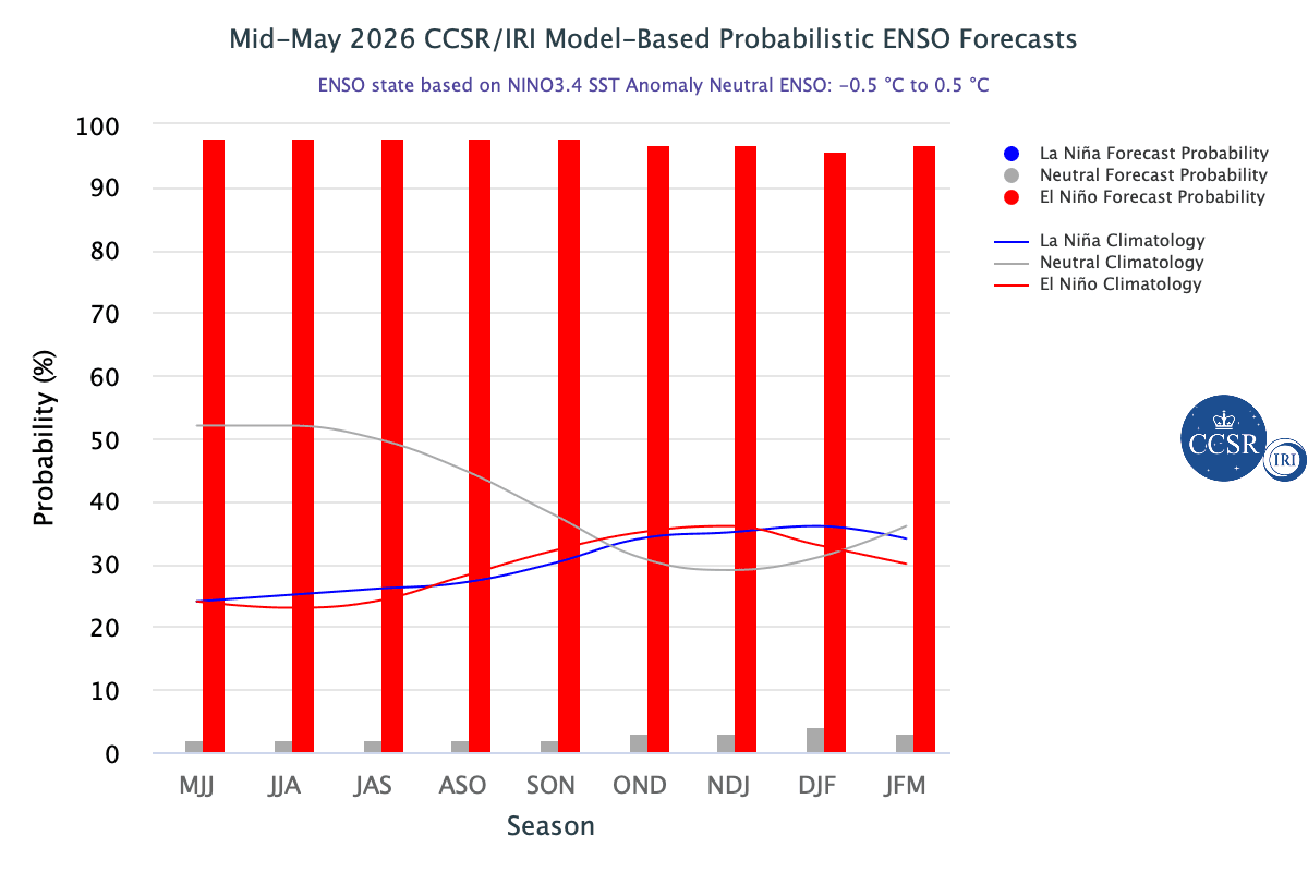
ENSO forecasts issued during the spring season are less reliable because the ocean-atmosphere system is in transition and therefore may generate eddies. However, the model predictions during the second half of May and later sit past that window, and the forecasts become more reliable with a fair degree of confidence. Now, the important aspects of the event are its arrival time and amplitude. There is a consensus building up among scientists that El Nino is an inevitable outcome this season. Yet, unpredictability still hangs around, and the prediction centers are much less definite about how strong the event will become.
El Nino has categories of weak, moderate, strong and very strong, and so far, no single strength category has exceeded a 37% chance. This is what leads to substantial uncertainty about the peak strength and its timing. Notwithstanding, the explicit point still remains that a stronger El Nino does not guarantee strong impacts; it only offers assurance that occurrence of the event is ‘most likely’.
The strength of the event is marked by the degree of tight coupling between ocean and atmosphere during summer and the grade of weakening of trade winds, which in turn reinforces warming of the ocean surface. These finer inputs are still getting collated and results are awaited and so, the assessment is offered with caution, as of now.
ENSO : El Nino is a warming of the central and eastern Pacific Ocean but most of its reverberations strike far from the place of origin. Also, there is a physical lag between the appearance of ocean signal warming, which normally happens during spring and early summer of the Northern Hemisphere, and its consequences, which typically build through the second half of the year and peak around the turn of the calendar. So, the warming building up in the Pacific now may trigger its broadest global impact around late 2026 and early 2027. That is how it is feared that 2026 and 2027 are likely to get figured among the hottest years of this decade.
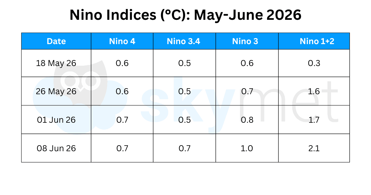
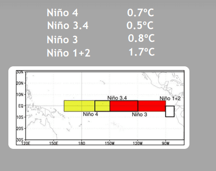
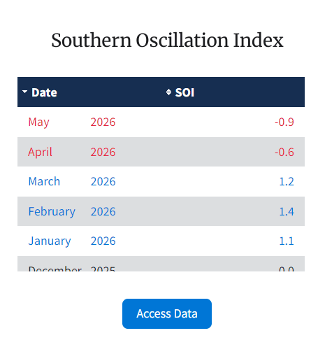
Since mid-April 2026, near-to-above average equatorial Sea Surface Temperatures have persisted across the central to eastern Pacific Ocean. Recently, positive SST anomalies have increased. The anomaly in the Nino 3.4 region has risen to 0.7°C, the highest since April 2024, and Nino 1+2 has crossed 2°C, the highest since December 2023. The atmospheric arm of ENSO, represented by the Southern Oscillation Index (SOI), is also getting aligned. Its latest average value for the month of May 2026 was -0.9. The index is following a typical El Nino pattern and is likely to increase in magnitude as the Nino indices grow stronger.
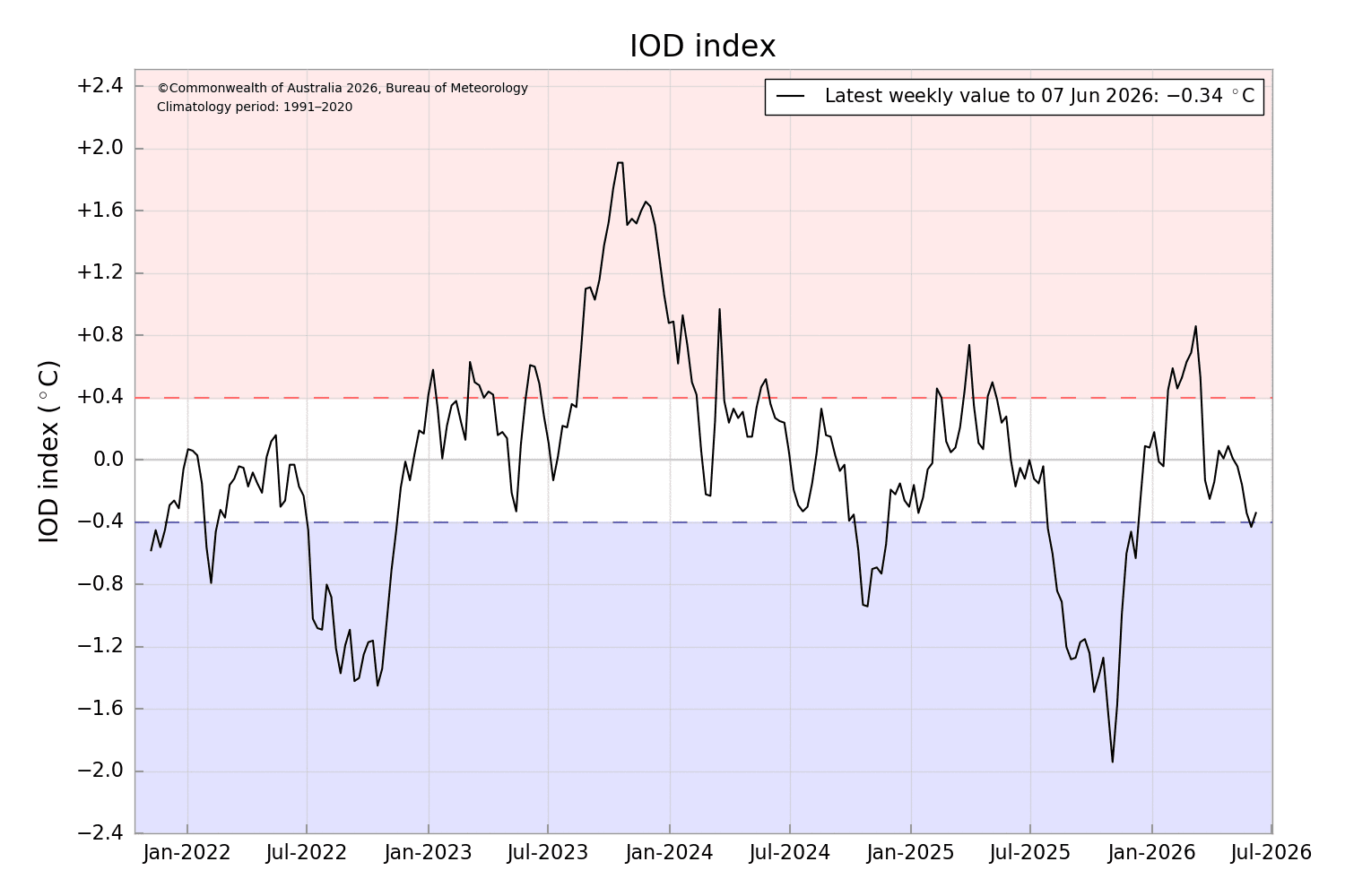
IOD : The mismatch between the model-based probabilistic IOD forecast and the actual index value continues. As per the model predictions, probabilities of the negative IOD phase remain negligible throughout the forecast period. The transition from neutral towards positive IOD is broadly consistent with the ENSO outlook. Usually, the IOD turns positive with adequate amplitude during dominant El Nino conditions. The latest value of the IOD index for the week ending 07th June 2026 was -0.34°C, marginally higher than the previous week’s reading of -0.43°C. The index is expected to turn neutral in mid-July 2026.
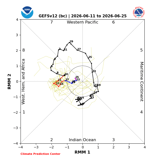
MJO : The Madden-Julian Oscillation lived through an active phase in June while over the Western Pacific and Africa in Phase 7 & 1. The dynamical model MJO index forecasts show a wide range of solutions, with the majority of them pushing for weakening of the MJO signal over the next one or two weeks. It is promising re-amplification towards the fag end of June or the start of July, albeit with tentative caution. The intra-seasonal signal may lessen the potential for monsoon disturbances over the Indian Seas. It is unlikely to provide any stimulus to the monsoon current across both the Arabian Sea and the Bay of Bengal.
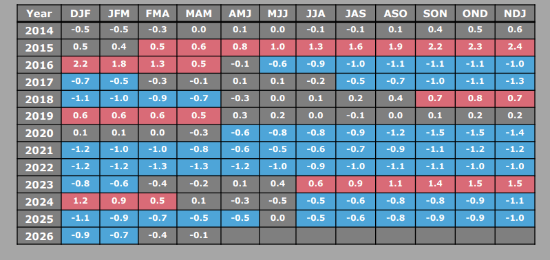
The worldwide agencies are emphatically alarming about the upcoming strong El Nino event. The Japanese weather agency Jamstec has even formally announced the onset of El Nino, though it appears a little premature. As per CPC, the ONI for the quarter Mar-Apr-May is -0.1°C, too low for the El Nino phenomenon. And, the Nino 3.4 index has barely reached the threshold mark. BoM criteria for El Nino also remain unfulfilled. Based on the rapid warming of the Pacific Ocean, it may be right to say that the process has begun.


