El Nino Intensity Remains Unpredictable: Peak Strength Window Tentative Too

Key Takeaways:
- El Niño conditions are strengthening faster than previously anticipated across the equatorial Pacific Ocean.
- The IRI ENSO forecast assigns a 98% probability of El Niño during May–July 2026, with persistence through the year.
- SST anomalies, particularly in the Nino 1+2 region, have surged sharply, indicating a stronger warming phase ahead.
- While El Niño poses a significant threat to the Indian monsoon, IOD and MJO conditions will also influence seasonal rainfall outcomes.
The equatorial Pacific Ocean is rapidly transitioning into El Niño conditions. A full-blown El Niño may evolve much earlier than expected based on previous timelines.
The sharp warming, both at the surface and sub-surface levels, could expedite the strengthening of the phenomenon with little margin for error. It is becoming increasingly likely that this year will bring an all-pervasive El Niño, striking the entire Niño region with extreme temperature anomalies. The overwhelming model projections of the phenomenon are raising the Indian monsoon risk beyond what was assessed earlier.
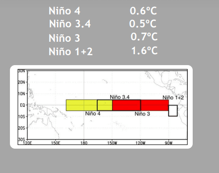
Nino indices are monitored over a large area in the equatorial Pacific Ocean. The area spans nearly 17 million sq. km, located on either side of the equator between 160°E–80°W and 5°N–5°S, with the exception of Nino 1+2, which lies between 0°–10°S. The monsoon regime, which normally gets impacted by the ENSO state of the Pacific Ocean, spans between 35°N–25°S and 30°W–170°E.
The location of El Niño's warming is also critical to the strength of the monsoon; if it is farther east in the Pacific, it could have less of an effect on India’s monsoon. The worst effect is anticipated when warming is observed more over the Central Pacific and cooling occurs on either side over the East and West Pacific (Modoki El Niño). But right now, it appears that it is going to be a basin-wide event, like the standard El Niño pattern, which will affect the monsoon in India, Indonesia, and West Africa. El Niño affects both the tropics and higher latitudes, but the tropics are more vulnerable to its adverse impacts. El Niño, in any shape, is never kind to the Indian monsoon, but its least impact is during a ‘Canonic’ El Niño, wherein the Eastern Pacific Ocean warms more than the Central and Western Pacific Ocean during the full-fledged phase of the event.
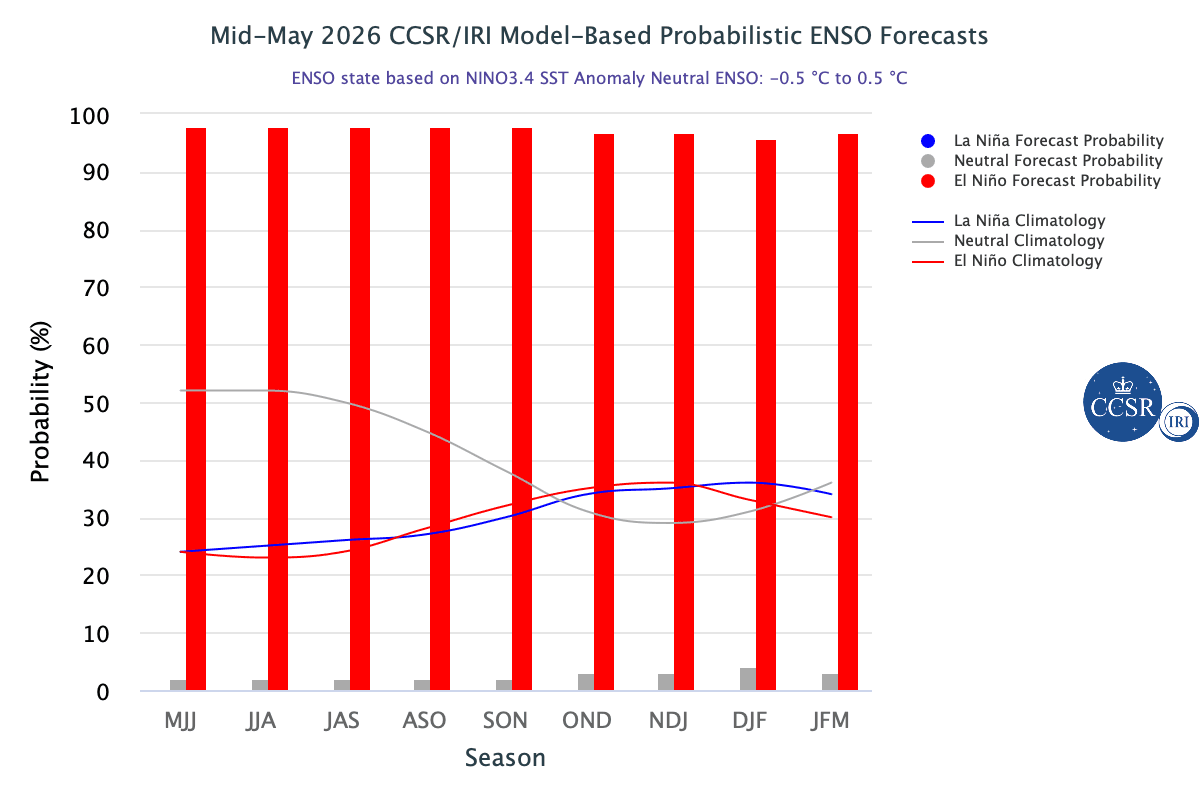
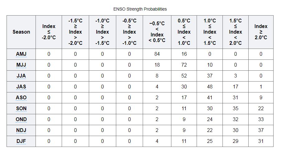
ENSO: It is a little early to predict the intensity and the window of peak strength of El Niño. Invariably, El Niño and La Niña events tend to reach their maximum strength during October–February. The IRI ENSO plume forecast assigns a very high probability of 98% to El Niño during May–July 2026. El Niño conditions are then likely to persist through the remainder of 2026, with forecast probabilities consistently maintained above the 90–95% range. This is a very rare occurrence and hardly finds any parallel during this century.
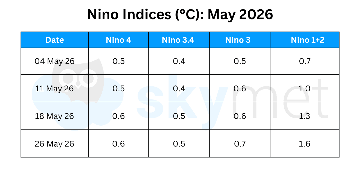
The SST anomalies remain near the borderline El Niño threshold in the central equatorial Pacific. The Nino 3.4 index has retained last week's mark of 0.5°C. The Nino 1+2 anomaly has risen sharply to 1.6°C, the highest value recorded so far this year. The sharp warming strongly indicates that the currently near-neutral seasonal averages will rise substantially in the coming weeks, making a clear shift from ENSO-neutral to El Niño conditions.
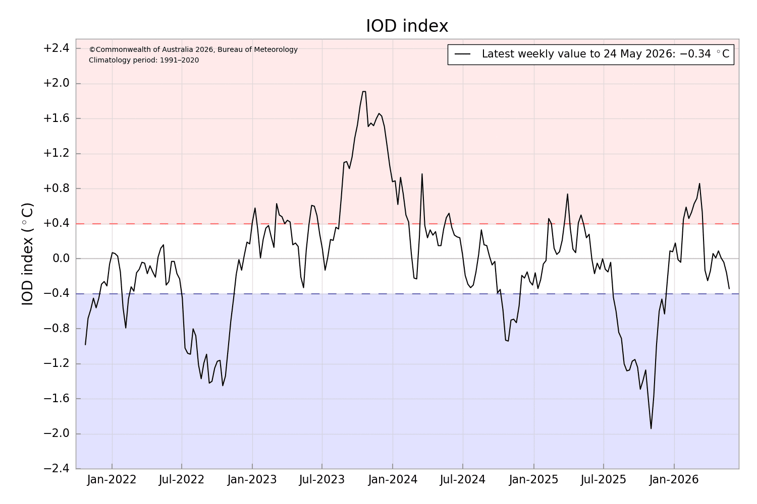
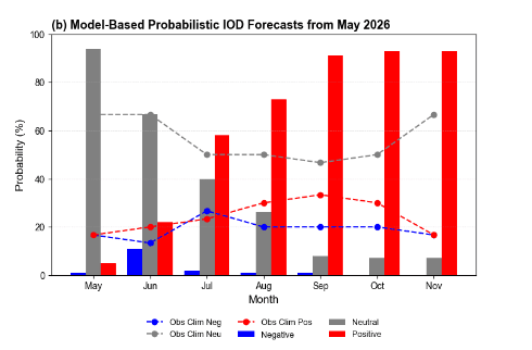
IOD: The DMI has risen steadily from its negative-phase peak in October 2025, gradually weakening through late 2025. The index had turned positive, albeit marginally, at the start of 2026 between January and March 2026. Neutral conditions have prevailed for about the last 10 weeks. Forecasts indicate that the IOD will remain neutral in June 2026, with an incremental tendency toward positive IOD conditions. The latest value of the index for the week ending May 24, 2026, was -0.34°C.
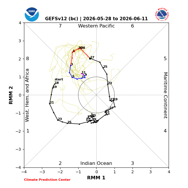
MJO: The MJO is propagating eastward and has moved from the Maritime Continent to the Western Pacific. It is likely to stay over the Western Pacific until the first week of June, retaining moderate amplitude. Such an event would also be associated with westerly wind anomalies over the Western Pacific, which could further warm the tropical Pacific and reinforce the development of El Niño.
The El Niño effect is likely to pick up at a faster rate, and the chances of the monsoon being adversely affected are becoming higher. However, El Niño is not the only factor affecting different weather systems, including the monsoon, and other parameters such as the IOD and MJO need to be weighed adequately. Historically, El Niño has impacted the monsoon on two-thirds of the occasions it has occurred. It has a past record of striking the northern and central parts severely while remaining comparatively merciful to the southern and northeastern parts of the country.