How Strong Will El Niño Be: Likely Impact on Monsoon


Representational Image: AI-Skymet
Key Takeaways:
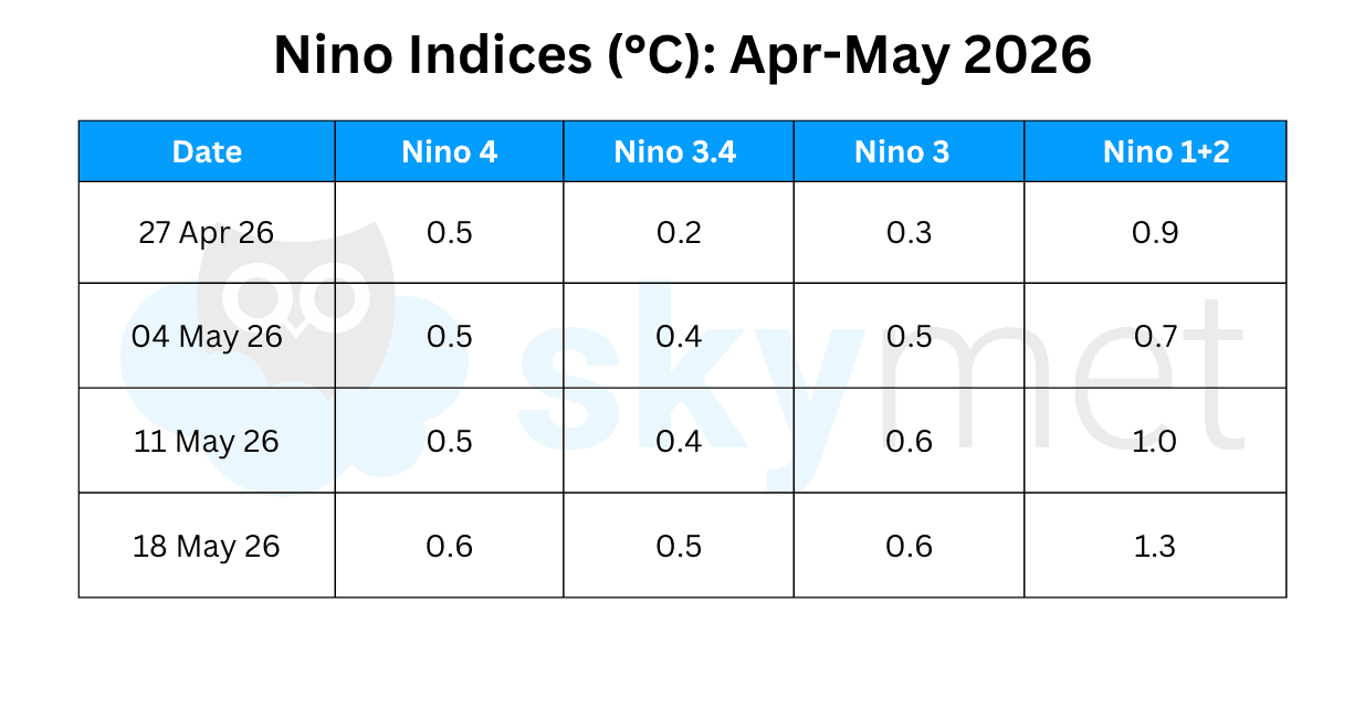
- Central Pacific temperatures have risen by over 1°C since January, marking the fastest warming trend of this century.
- The Niño 3.4 index has touched +0.5°C for the first time since May 2024, signalling a possible transition towards El Niño conditions.
- NOAA CPC projects weak to moderate El Niño during the Indian Summer Monsoon, with chances of a stronger El Niño increasing later in 2026.
- Historical data suggests that even strong El Niño events do not always guarantee drought conditions over India.
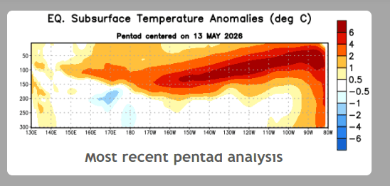
Likely emergence of a strong El Niño is gaining attention. The analysis shows that water temperatures have already climbed more than 1°C since January in the Central Pacific, the greatest rate of warming this century. As per NCEP CPC, the equatorial sub-surface temperature index (average from 180°-100°W) increased for the sixth consecutive month, with widespread, significantly above-average sub-surface temperatures across the equatorial Pacific.
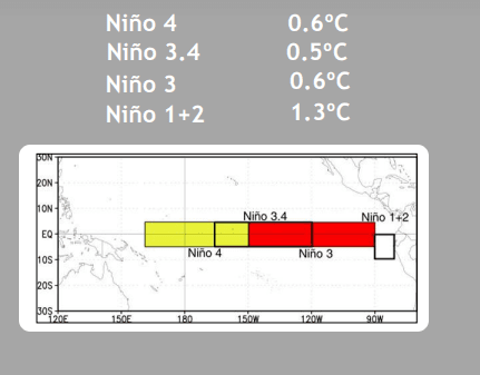
The NMME average, including the NCEP CFSv2, favours El Niño to form by next month and persist through Northern Hemisphere winter 2026-27. The findings say that while confidence in the occurrence of El Niño has increased since last month, there is still substantial uncertainty regarding the peak strength of El Niño. The strongest El Nino events essentially need strong ocean-atmosphere coupling and its sustenance through the Northern Hemisphere summer. The emergence of a very strong El Niño hinges on this aspect, which is subject to scrutiny in the coming months from June to September.
El Niño severity is directly and positively correlated with surface temperature anomalies. Very strong El Niño events are classified when the temperature anomaly reaches or exceeds 2°C. In modern history, since 1950, there have been only six ‘Super El Nino’ events of this grade: 1957-58, 1972-73, 1982-83, 1991-92, 1997-98, and 2015-16. Out of these, there was normal monsoon rainfall on two occasions, below normal on one, moderate drought on two, and severe drought on one occasion. Based on discussions, the CPC inferred that stronger El Nino events do not ensure strong weather and climate impacts, though they commonly make certain impacts more likely.
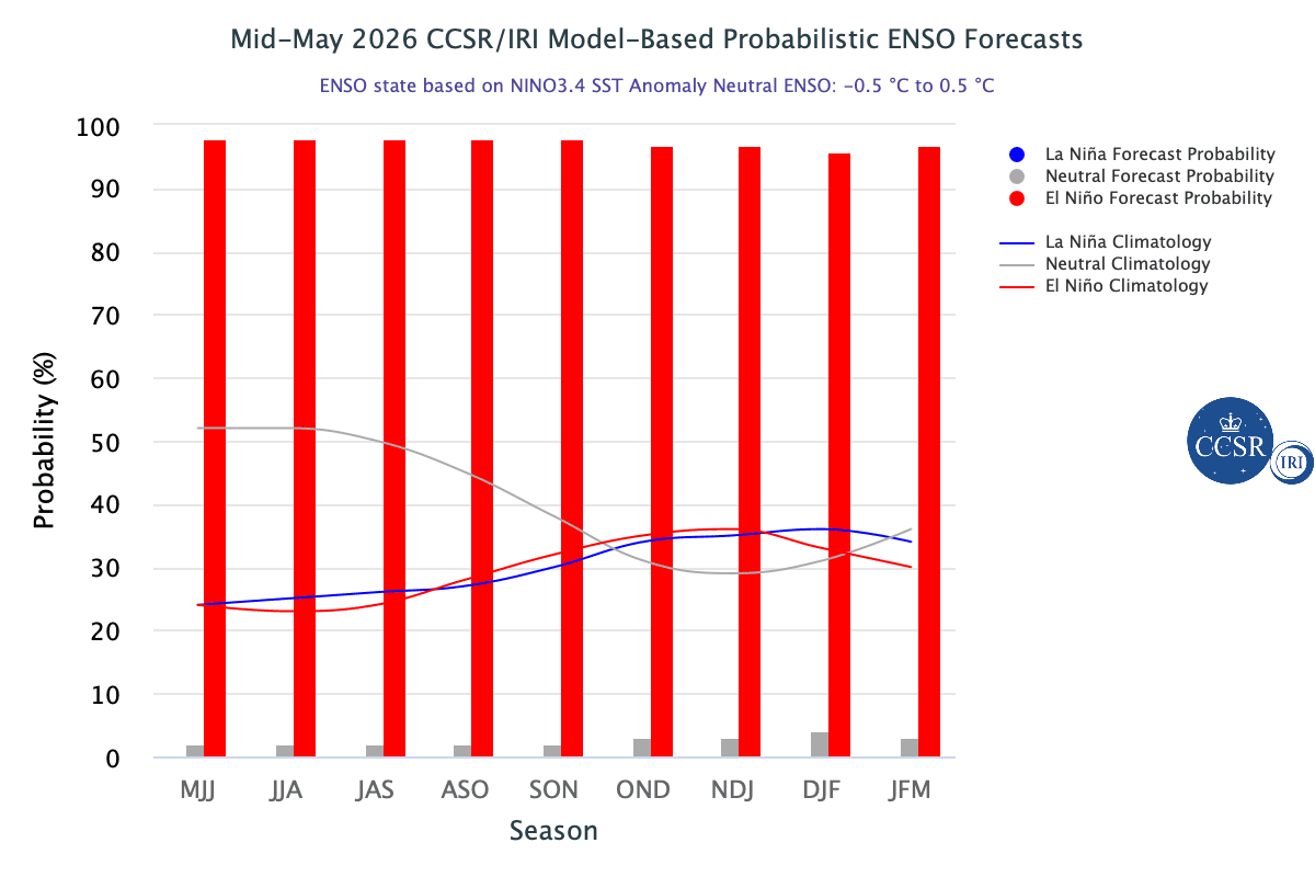
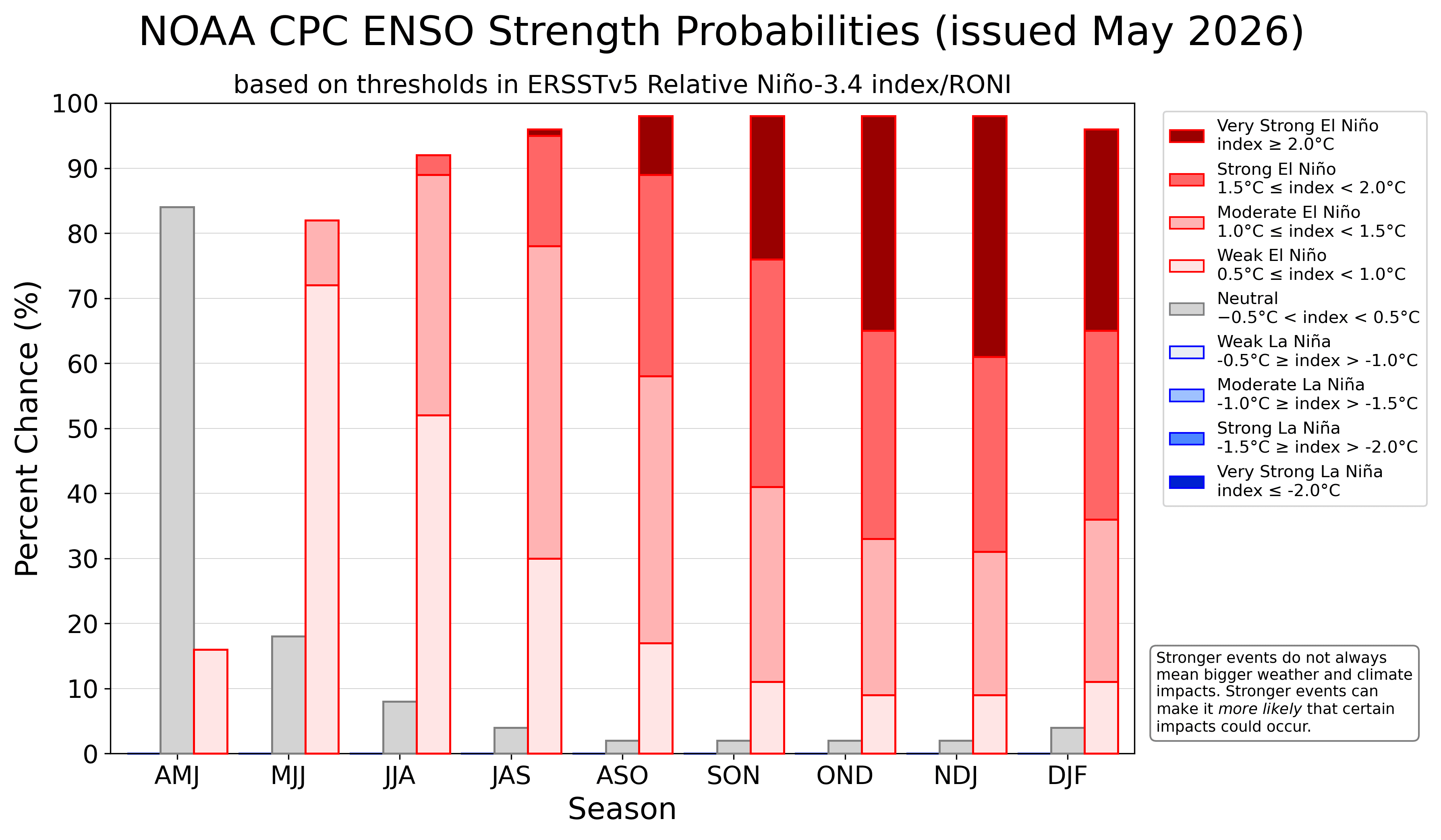
ENSO: NOAA CPC has issued ENSO strength probabilities for the upcoming event. The very strong phase of El Nino will likely occur after the Indian monsoon season. There is a 30-40% probability for El Nino to become very strong during the fall of this year and the start of 2027. The Indian Summer Monsoon will begin with a 70% probability of weak El Nino, a 10% probability of moderate El Nino, and the remaining 20% with ENSO-neutral conditions. However, halfway through the season, there will be an equal share of weak and moderate El Nino events. The closing weeks of the monsoon will witness nearly a 40% probability of strong or very strong El Nino.
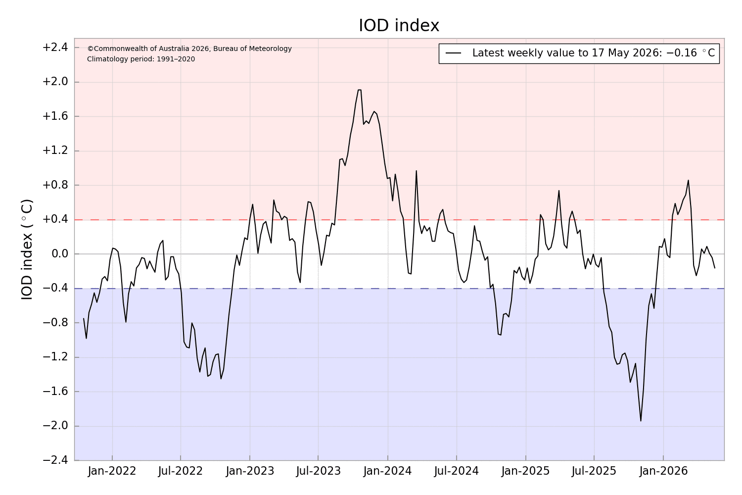
IOD: IOD events are identified using the Dipole Mode Index (DMI), which is defined as the difference between western and eastern SST anomalies along the equatorial Indian Ocean. The DMI index is maximum during October and November. The amplitude of the DMI index is minimum during March-April, starts increasing from May, and peaks during the autumn of the Northern Hemisphere. This is the normal cycle of IOD.
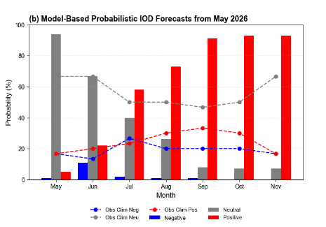
The IOD index normally remains between +/-1°C and occasionally reaches or exceeds 2°C, as it happened in 2019 and 2023. Going against the usual pattern, the index has remained nearly zero for the last seven weeks. The latest value of the IOD index for the week ending 17 May 2026 was -0.16°C. It is likely to remain within neutral bounds until the end of June.
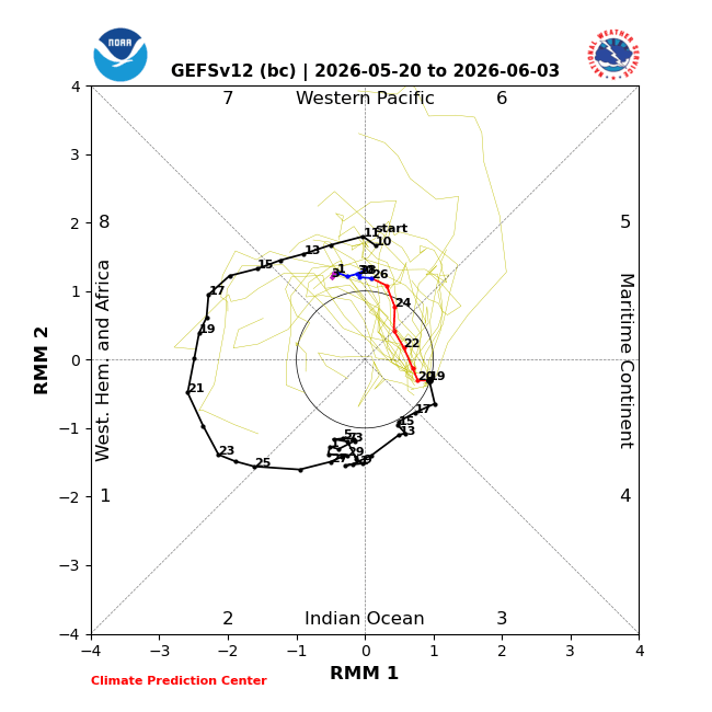
MJO: The Madden-Julian Oscillation had nearly stalled over the Indian Ocean until the middle of May 2026. The low-frequency signals earlier interfering destructively had derailed the pulse. Now, the MJO signal is expected to organise while propagating from the Maritime Continent to the Western Pacific. The forecast MJO evolution, with a likely increase in amplitude, supports enhanced chances for tropical cyclogenesis in the Western Pacific and Indian Seas.
Every El Nino need not necessarily disrupt the Indian monsoon. However, the current El Nino event is likely to be the strongest one in terms of temperature anomalies. Since 1950, the strongest El Nino in 1982-83 had a temperature anomaly of +2.5°C. In 1972-73, the peak anomaly was 2.3°C. While 1972 witnessed a severe drought (76% of LPA), the seasonal rainfall in 1982 was 85% of LPA. The strongest temperature anomaly does not have a robust correlation with completely ruining the monsoon. In the past, even moderate El Nino events have caused severe drought, as happened in 2009. During the very strong El Nino events of 1957-58 and 1997-98, the seasonal rainfall was normal at 98% and 102% of LPA, respectively.



