El Nino Warming Outweighs La Nina Cooling: Pacific Temperatures Set to Rise

Key Takeaways:
- Strong El Niño conditions are strengthening and are expected to persist into the Northern Hemisphere winter 2026–27.
- Climate change may amplify the impacts of El Niño despite not increasing its frequency or intensity.
- A positive Indian Ocean Dipole is likely to emerge in July and become well established by September.
- The Madden-Julian Oscillation is unlikely to aid Bay of Bengal system formation during the latter half of July.
- Forecast Validity: Until Next Update.
There is no evidence that climate change increases the frequency or intensity of ENSO events. However, it can amplify associated impacts because a warmer ocean and atmosphere increase the availability of energy and moisture for extreme weather events such as heatwaves and heavy rainfall. As per the preliminary estimates, the upcoming episode of strong El Niño is expected to raise the Pacific Ocean temperature by as much as 1.5°C during the peak period. Researchers have proved that there is an asymmetry in the El Niño-Southern Oscillation, the confluence of winds and water currents that create warm El Niño events and cooler La Niña episodes.
The overall temperature of the Pacific Ocean has increased, albeit marginally, over the last couple of decades. This supports the fact that the warming of the equatorial Pacific Ocean on account of El Niño spreads its wings and area, and outweighs the cooling zone associated with La Niña. Better modelling of the mechanisms that push El Niño events to be warmer could provide better insight into the climate system and improve El Niño predictions.
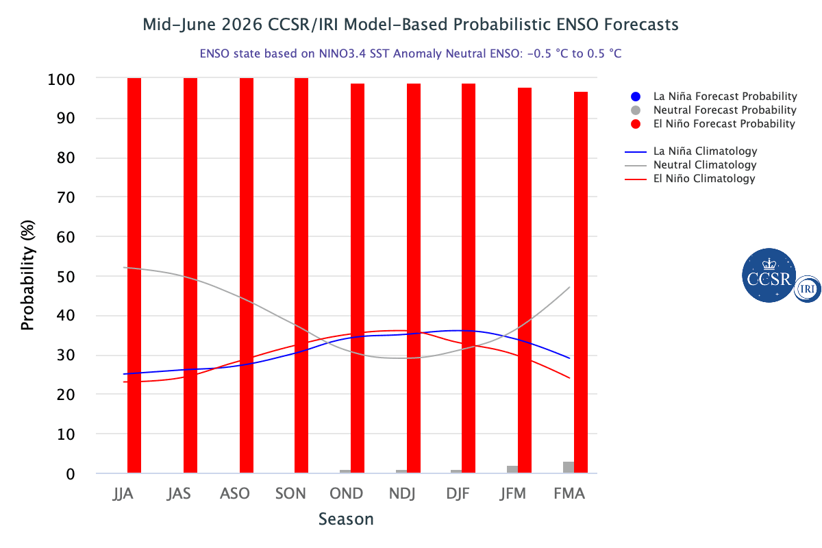
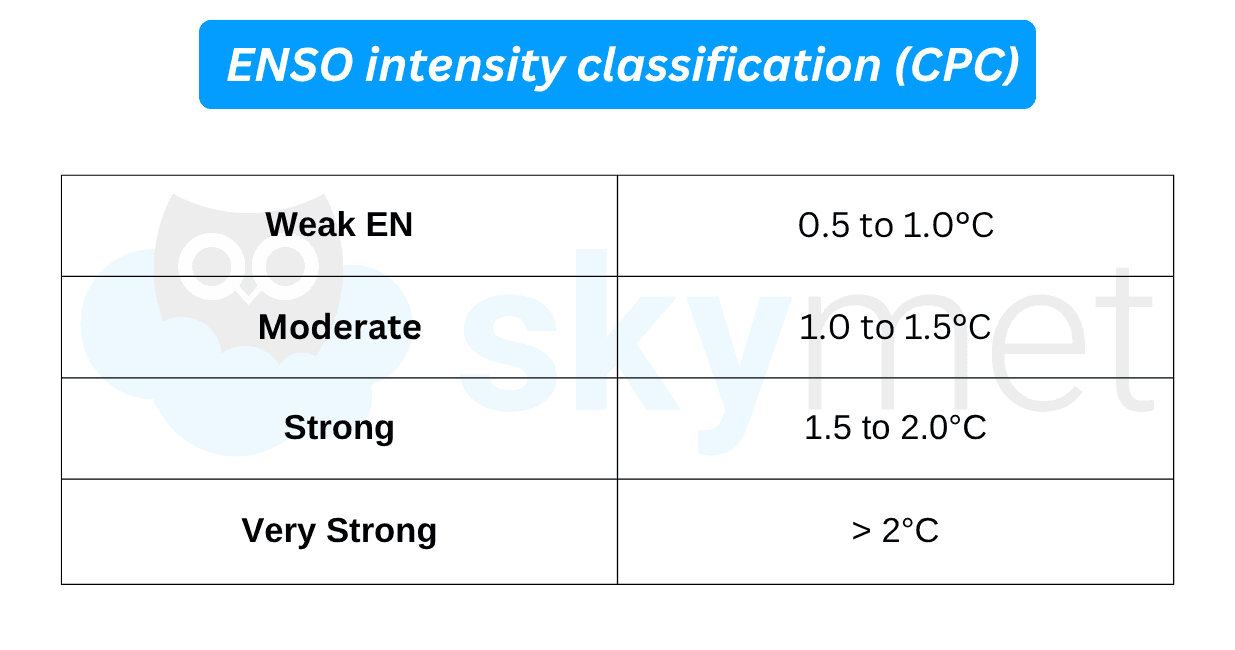
ENSO: El Niño conditions are strengthening across the tropical Pacific, with SST anomalies in the Niño 3.4 region showing a steady upward trend. Oceanic and atmospheric indicators are becoming increasingly aligned, supporting further intensification of the ongoing El Niño event. However, the forecast of ENSO strength remains an estimate arrived at with consensus-based models using a set of Niño 3.4 sea surface temperature anomaly thresholds to indicate weak, moderate, strong and very strong El Niño categories. Amid fluctuating temperature anomalies in the Niño region, it is an enormous task to commit to the likely period and strength of the peak intensity of the El Niño event. The challenge becomes bigger for warming episodes in the equatorial Pacific Ocean. The Climate Prediction Center defines the ENSO intensity classification based on TONI (Tropical Ocean Niño Index), which is an area-averaged sea surface temperature anomaly over the Niño 3.4 region (5°S–5°N, 170°W–120°W). The intensity classification is:
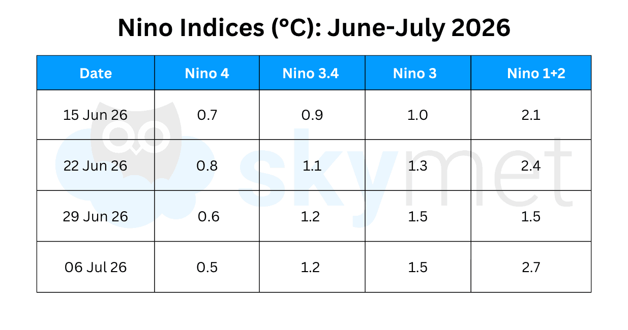
Equatorial SSTs are above average across the central and eastern Pacific Ocean. The atmospheric circulation is firmly aligned with consistent El Niño conditions. El Niño conditions are expected to strengthen into the Northern Hemisphere winter of 2026–27. The Niño indices across the equatorial Pacific Ocean have remained stable, unlike in the last couple of weeks, and no sharp rise has been noticed in the anomalies of the Niño 3 and Niño 3.4 regions.
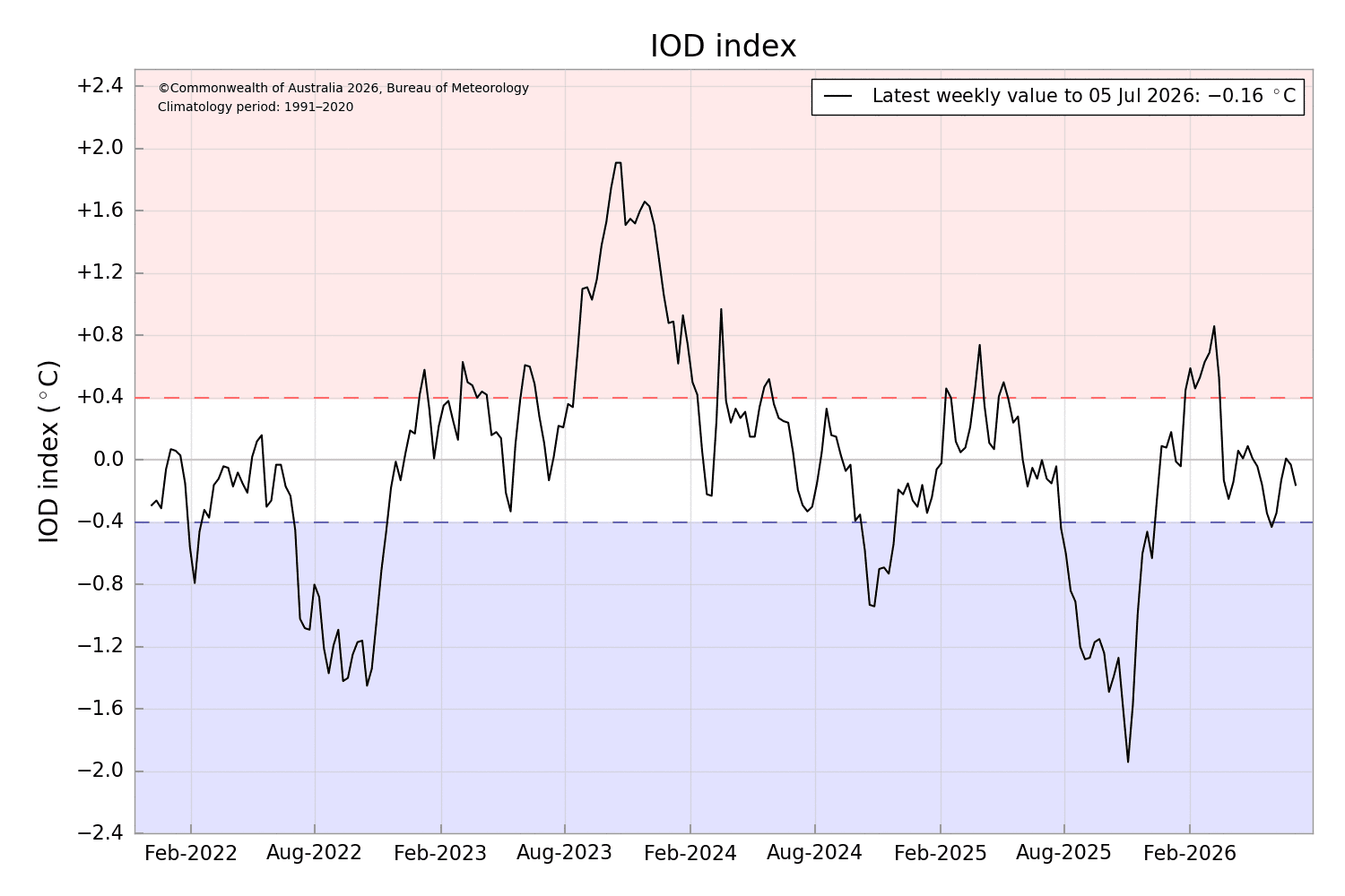
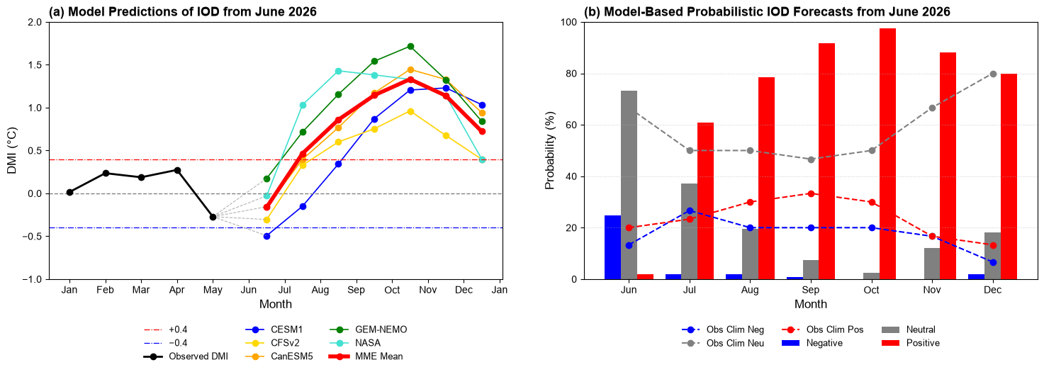
IOD: The Indian Ocean Dipole is an inherent mode of climate variability over the Indian Ocean, independent of the El Niño/La Niña phenomenon. The IOD forecast generated based on all ensemble members combined from the contributory models predicts climatological probabilities. As per this, neutral IOD conditions are forecast to turn into positive IOD in July, albeit remaining marginally above the threshold mark of 0.4°C. From August through September, the probability of a positive IOD continues to rise to over 90% by September, while neutral conditions decline to less than 10%. The maximum amplitude of the IOD temperature anomaly is likely to remain between 1.0°C and 1.5°C. The latest value of the index for the week ending 05 July 2026 was -0.16°C.
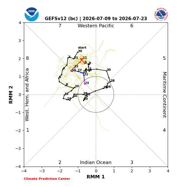
MJO: The dynamical models indicate a stagnant pattern of the MJO over the Western Pacific in Phase 7. This persistent pattern will favour continued chances of tropical cyclone development over the East and West Pacific regions. The MJO signal is likely to reduce in amplitude and move back to the inner circle during the last week of July. It is unlikely to offer any support for the development of Bay of Bengal systems.
Super Typhoon Bavi in the Western Pacific moved past the Philippines and Taiwan and struck the southeast coast of China. Earlier, this powerful typhoon diverted the monsoon flow and restricted the formation of fresh systems over the Bay of Bengal. Consequent to the weakening of Bavi following landfall, the deck will be cleared for a fresh low-pressure area over the North Bay of Bengal early next week.