Delhi Records First Forty Degree Of May: Mercury To Soar Next Week


Representational Image: AI-Skymet
Key Takeaways:
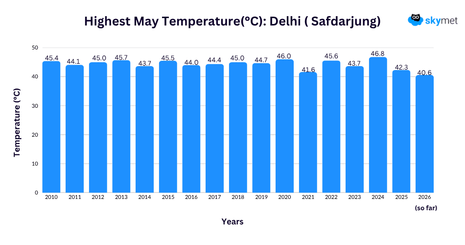
- Delhi recorded its first 40°C temperature of May with Safdarjung touching 40.6°C.
- Dust storms and gusty winds have become more frequent over Delhi/NCR.
- Temperatures may cross 43°C during the first half of next week.
- Strong surface winds and loo conditions are expected to prevail through the week.
Pre-monsoon weather hazards have increased over the Delhi area in the last 2–3 days. Thunderstorms, dust storms, heat, gusty winds and lightning incidents have become frequent and intense too. Yesterday, the base station Safdarjung recorded a maximum temperature of 40.6°C, the first 40-degree mark of this month. Also, the day temperature exceeded the normal for the first time in May, albeit marginally. The temperature is likely to increase significantly at the start of next week.
Delhi/NCR was struck by a dust storm of moderate strength late last night. Gusty winds accompanied the storm, but there was no rainfall as such. There was no major drop in the night temperature and the minimum temperature was arrested at 26.2°C, about a degree above normal. Morning temperatures are likely to stay around 26°C (+/- 1°C) for the next one week.
Breaching the 40°C mark in the month of May is quite usual for Delhi. Since 2010, the base station Safdarjung has recorded the lowest maximum temperature of 41.6°C in 2021. Halfway through the month, Delhi has just managed to reach 40°C this season. The temperature is expected to breach the 43°C mark during the first half of next week. In the past, Delhi has crossed the 45°C mark on eight occasions since May 2010.
A cyclonic circulation is marked over North Rajasthan and adjoining Punjab in the lower levels. Another circulation is lying over Central Uttar Pradesh. An east-west trough continues to run in close proximity to Delhi up to 5,000 ft height. There is a chance of thunderclouds developing late in the night, resulting in gusty winds and dust storms. From tomorrow onwards, the trough will shift far to the north of Delhi, at a safe distance to trigger any weather activity. Temperatures will rise to remain above 40°C throughout the week. Surface winds will become strong and “loo” conditions are likely over Delhi/NCR.
Trending: