Paradigm Shift In ENSO Events: La Niña Outnumbers El Niño

Representational Image: AI-Skymet
Key Takeaways:
- El Niño is transitioning from weak to moderate and may become strong by late September.
- The probability of a very strong El Niño exceeds 70% during the September-January period.
- The Indian Ocean Dipole remains neutral at -0.06°C, offering little support to offset El Niño.
- India's monsoon has already recorded a 40% rainfall deficit in June, with greater risks expected during the latter half of the season.
- Forecast Validity: Until Next Update.
Historically speaking, El Niño and La Niña events tend to develop during the period April-June, and they typically reach their maximum strength during October-February. ENSO events generally persist for 9-12 months, though they occasionally persist for up to two years or more. This is more applicable to La Niña, which has outnumbered El Niño events since the turn of the century. Even the cycle and periodicity of ENSO events seem to have taken an aberrant course, and they no longer follow the earlier timelines.
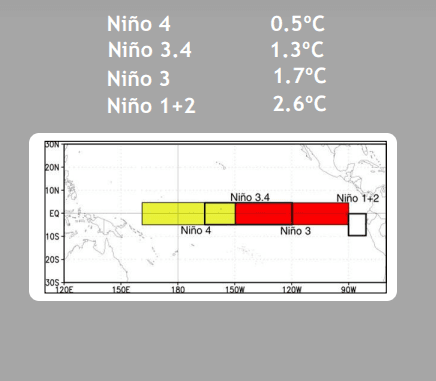
By historical standards, for a full-fledged El Niño or La Niña episode, the RONI (Relative Ocean Niño Index) must exceed the temperature anomaly threshold of ±0.5°C for a period of at least five consecutive overlapping three-month seasons. The Climate Prediction Center (CPC) considers El Niño or La Niña conditions to occur when the monthly relative Niño 3.4 departures meet or exceed ±0.5°C, along with consistent atmospheric features. These anomalies must also be forecast to persist for three consecutive months.
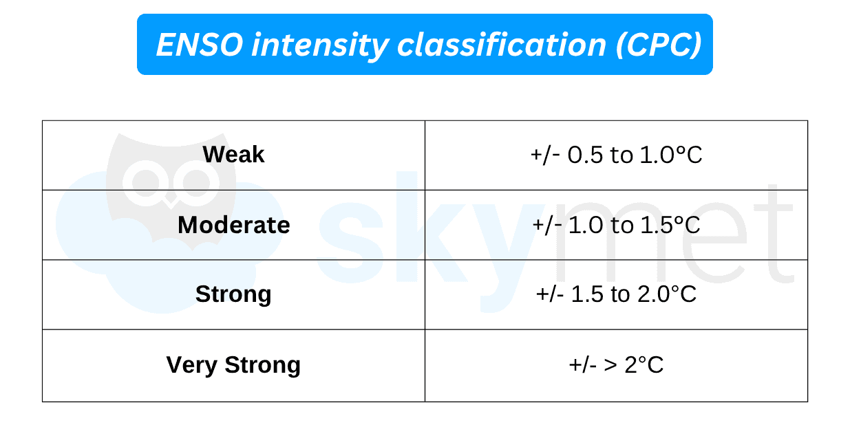
Quite often, from start to finish, ENSO events invariably spill over into the following year. Accordingly, each El Niño or La Niña event spans two consecutive years, such as 2002-03, and so on. Also, the strength of the event is directly correlated with the temperature anomaly, as follows:
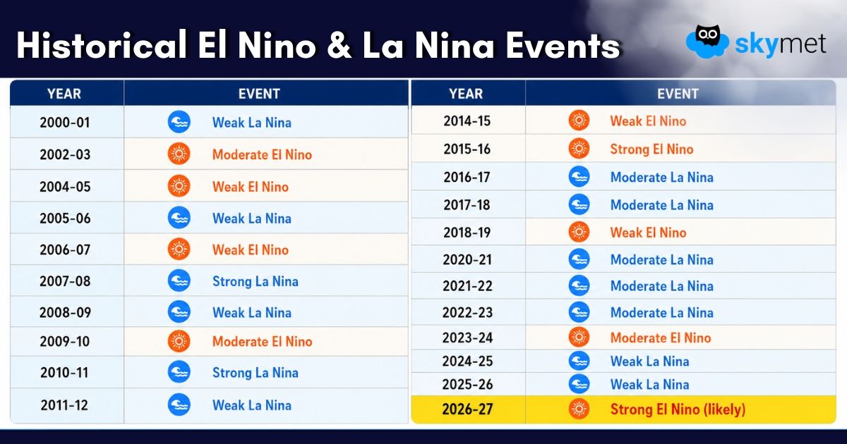
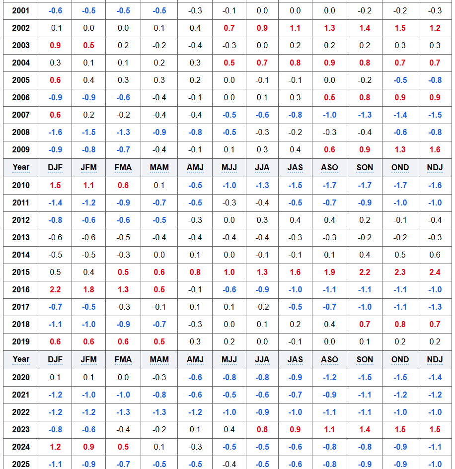
The dataset for El Niño/La Niña events since the start of this century is as follows:
ENSO: No two ENSO events behave identically in terms of their impacts over different parts of the globe. There have been six episodes of 'Super' El Niño since 1950. The monsoon rainfall was normal in two, below normal in one, drought in two, and severe drought in one episode. The most severe drought of 1972-73, with seasonal rainfall of 76% of the Long Period Average (LPA), had a temperature anomaly of +2.3°C.
The 1997-98 'Super' El Niño became one of the strongest ever observed, contributing to floods, droughts, and wildfires across multiple continents. However, the Indian subcontinent miraculously escaped its fury and ended up with normal rainfall of 102% of the LPA. More recently, the powerful 2015-16 El Niño coincided with destructive Pacific hurricanes, Indonesian wildfires, and drought in Ethiopia, the Caribbean, and the Indian subcontinent.
The current El Niño episode of 2026-27 remains mysterious regarding its ultimate intensity and peak period. After all, El Niño does not cause the same chaos everywhere, but it does raise the likelihood of climate extremes across many regions. Even the strongest El Niño events do not lead to typical impacts everywhere, but stronger events can more significantly tilt the odds in favour of expected outcomes.
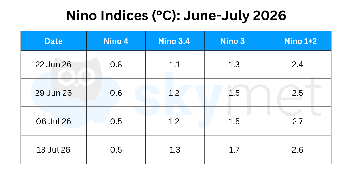
The temperature anomaly over Niño 3.4 and Niño 3 has increased marginally. El Niño is transitioning from a weak to a moderate phase. The event may remain within the moderate category during the monsoon season or, at best, just begin slipping into the strong category during the second half of September. The peak intensity is expected to occur sometime during the fall of the year.
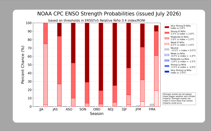
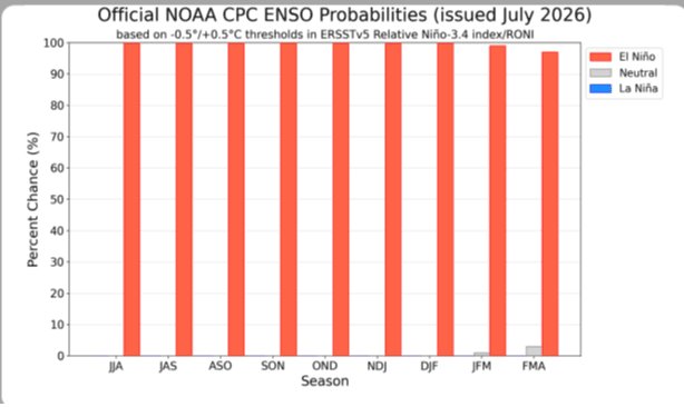
The probability of a strong El Niño during the June-July-August quarter is about 25%, while the probability of a very strong El Niño during the July-August-September quarter is 15%. The chances of a very strong El Niño increase to more than 70% during the September-October-November, October-November-December, and November-December-January quarters. This means that El Niño will continue to strengthen through the end of the year, with a 97% chance of persisting through early spring 2027.
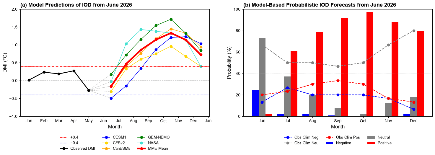
IOD: The variation in sea surface temperatures over the Indian Ocean drives global climate variability. The predictive skill of SST anomalies associated with the IOD is assessed using ensemble seasonal forecasts from a selection of contemporary coupled climate models that are routinely used for seasonal climate prediction.
IOD events generally reach their maximum amplitude during the September-October-November season. Skillful prediction is also limited to about one season in advance. Although large IOD events can sometimes be predicted further ahead, perhaps up to two seasons, that is not the likely scenario during the ongoing episode.
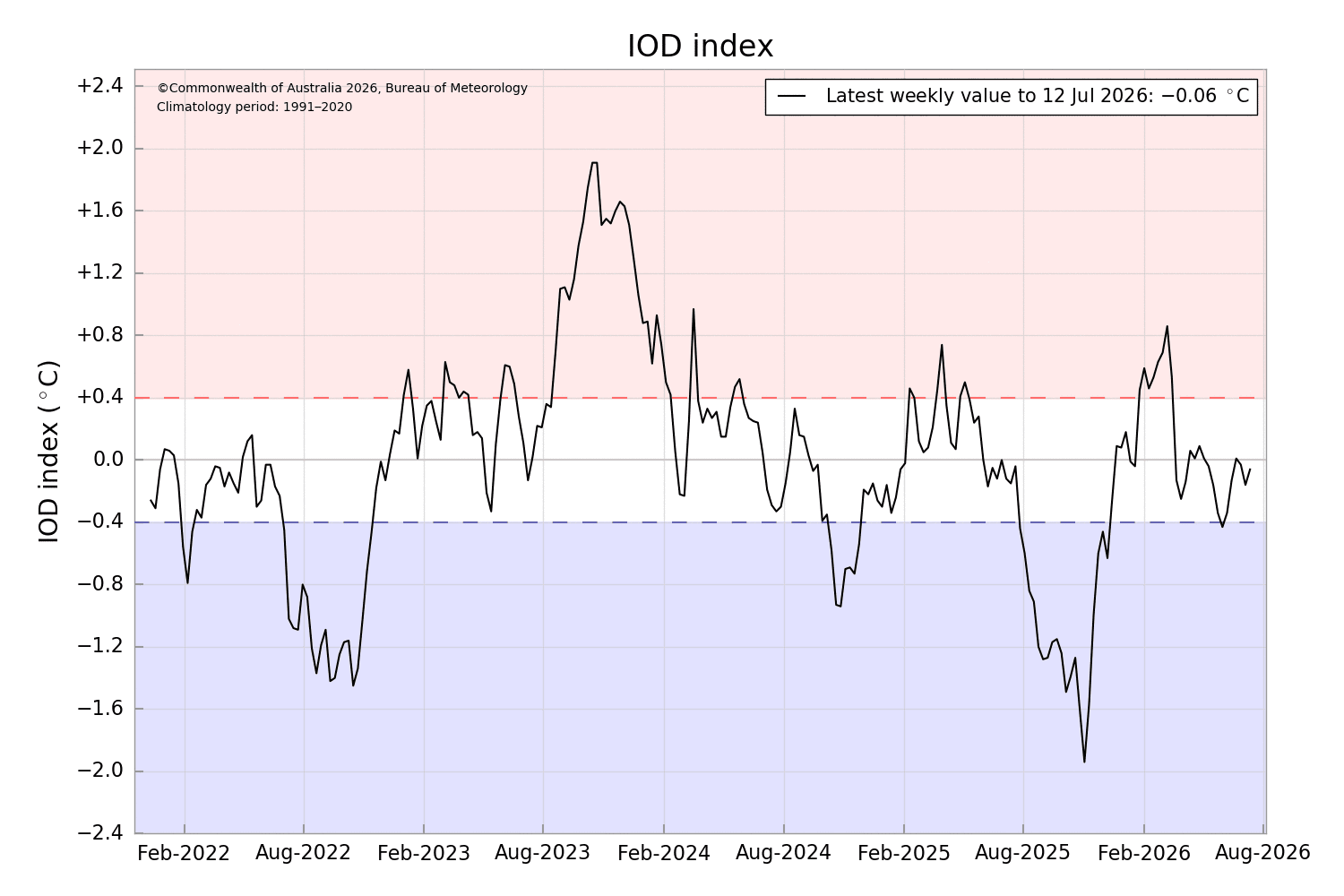
The Indian Ocean Dipole is currently neutral. As of 12 July 2026, the IOD index is -0.06°C.
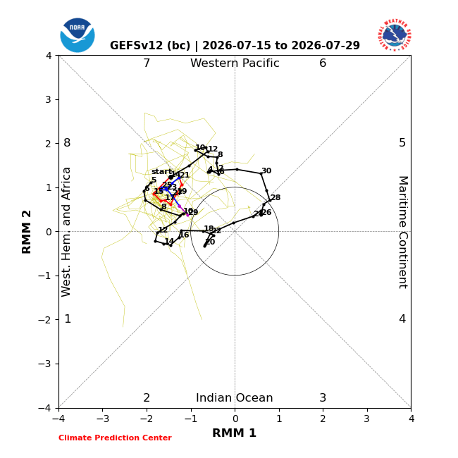
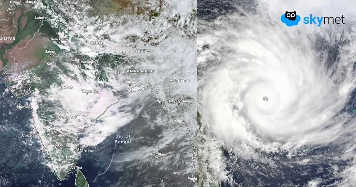
MJO: The Madden-Julian Oscillation continues to constructively interfere with the strong El Niño background conditions. Dynamical models generally favour the slow eastward propagation of the MJO into the Western Hemisphere, followed by gradual disorganization during late July. Conditions remain favourable for additional tropical cyclone development over the Western Pacific. However, forecast confidence for tropical cyclone development over the Indian Seas remains low.
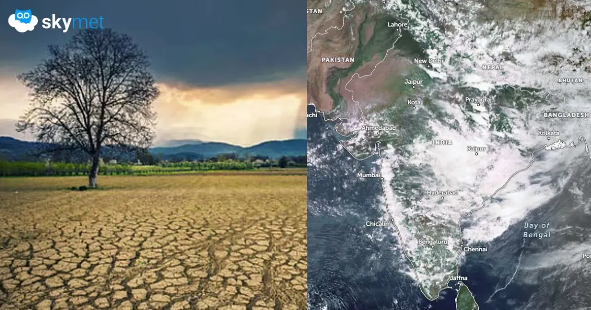
El Niño is transitioning from the weak to the moderate category. Its adverse impact is now becoming visible over the Indian monsoon. The month of June recorded the largest rainfall deficit of 40% since 2014. A skewed rainfall distribution is anticipated during July. The stakes may become even bigger during the second half of the monsoon.